NZ Topo - object class trig_pnt
This page describe the trig_pnt object class used to represent objects in the NZTopo topographic database.
Description
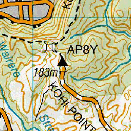
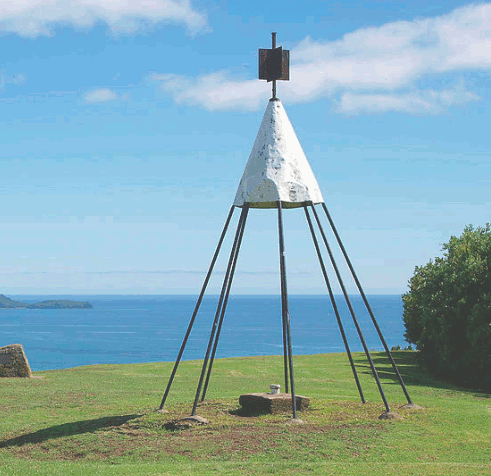
A structure on top of a hill, usually coloured black and white, used as a physical reference point by surveyors to determine location. The symbol shown on the map includes the elevation and trig identification code for beaconed trig stations. These topographic trig points are derived from New Zealand geodetic marks data which can also be accessed through the LINZ Data Service: [NZ Geodetic Marks](https://data.linz.govt.nz/layer/50787/) and [NZ Geodetic Vertical Marks](https://data.linz.govt.nz/layer/50784/).
Topo50 description
Only beaconed trigs are held in the data and shown on the printed maps.

Class attributes
| Attribute | Value |
|---|---|
| Object class | trig_pnt |
| Entity class | TRIG |
| Additional entity class | Not applicable |
| Object inheritance | simple_point |
| Entity source | US Standard Entity |
| Map series | Topo50 |
| LSLIFF object class | 196 |
Object attributes
| Attribute | LSLIFF code Shapefile field Data type |
Attribute description | Attribute values* | ||
|---|---|---|---|---|---|
| name | 1001 name string |
Trig identification code for beaconed trig stations. |
|
||
| name_macronated | 1140 macronated boolean |
Indicates whether the entry in the name_ascii field contains a macronated vowel. Where the value is "Y" go to http://www.linz.govt.nz/regulatory/place-names/find-place-name/find-m%C4%81ori-place-names-dual-names-and-alternative-names for a list of places or feature names within New Zealand that are gazetted and include macrons |
|
||
| name_ascii | 9000 name_ascii string |
Text data from July 2012 will be in UTF-8 format. If your system is not UTF-8 compliant, you will need to use this attribute, which has had any macronated vowels removed. | |||
| UFID | 1000 t50_fid integer |
A unique identifier for use on Topo50 data in the LINZ Data Service. This is not a universal ID. The intention is to manage these ID’s as persistent, however this is not guaranteed and there will be instances where what appears to be a minor change to a feature may result in a new ID being assigned. |
|
||
| elevation | 1021 elevation real |
Elevation of the trig station. |
|
* See explanation of attribute values for more information about how attribute values are represented.
Change log
| Feature version | Revised | Description |
|---|---|---|
| 1 | 2020-04-01 | Added new object class. |