NZ Topo - object class building_pnt
This page describe the building_pnt object class used to represent objects in the NZTopo topographic database.
Description
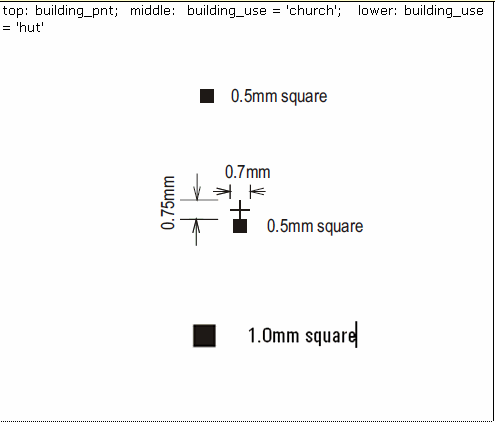
A relatively permanent walled and roofed construction.
Topo50 description
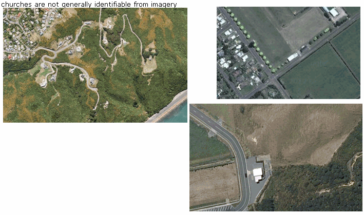
Only those significant either by their size or location are held in the data and shown on the printed maps. Of these building_pnt is used when the area is too small to be captured at 1:50,000 as a polygon feature Where a building is located close to a road, the point held in the data and shown on the printed maps may be offset from the road a distance of up to 30m. There are more buildings held in the data than shown on the printed map; text on the printed map will mask out the building symbol. Note also that a single building feature may represent one, two or a group of buildings in close proximity.
Topo250 description
Only those significant by their size or location are held in the Topo250 data and shown on the Topo250 printed maps; these are a generalised subset of the building_pnt and building_poly features shown on the Topo50 series.

Important information: The Department of Conservation or other authorities should be contacted for the latest information on tracks and huts
See also: building_poly
Class attributes
| Attribute | Value |
|---|---|
| Object class | building_pnt |
| Entity class | BUILDING |
| Additional entity class | BUILDING COMPLEX |
| Object inheritance | graphic_point |
| Entity source | Proposed change to US Entity |
| Map series | Topo50 Topo250 Ant50 |
| LSLIFF object class | 11 |
Object attributes
| Attribute | LSLIFF code Shapefile field Data type | Attribute description | Attribute values* | |||||
|---|---|---|---|---|---|---|---|---|
| name | 1001 name string | The name of the building, where known. Text data from July 2012 will be in UTF-8 format. If your system is not UTF-8 compliant, you will need to use the name_ascii attribute, which has had any macronated vowels removed. UTF-8 stands for Unicode Transformation Format-8. It is an octet (8-bit) lossless encoding of Unicode characters. UTF-8 encodes each Unicode character as a variable number of 1 to 4 octets, where the number of octets depends on the integer value assigned to the Unicode character. It is an efficient encoding of Unicode documents that use mostly US-ASCII characters because it represents each character in the range U+0000 through U+007F as a single octet. UTF-8 is the default encoding for XML. |
| |||||
| name_macronated | 1140 macronated boolean | Indicates whether the entry in the name_ascii field contains a macronated vowel. Where the value is "Y" go to http://www.linz.govt.nz/regulatory/place-names/find-place-name/find-m%C4%81ori-place-names-dual-names-and-alternative-names for a list of places or feature names within New Zealand that are gazetted and include macrons |
| |||||
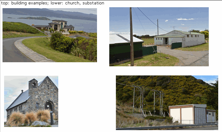
| building_use | 1014 bldg_use string | For substation example see powerline_cl page. For sewage plant see pond_poly page. Note: Other legitimate building use attributes will be added periodically. | See below | |||||
| building_status | 1013 status string | Values
|
| |||||
| name_ascii | 9000 name_ascii string | Text data from July 2012 will be in UTF-8 format. If your system is not UTF-8 compliant, you will need to use this attribute, which has had any macronated vowels removed. | ||||||
| UFID | 1000 t50_fid integer | A unique identifier for use on Topo50 data in the LINZ Data Service. This is not a universal ID. The intention is to manage these ID’s as persistent, however this is not guaranteed and there will be instances where what appears to be a minor change to a feature may result in a new ID being assigned. |
| |||||
| orientation | 1115 orientatn string | The orientation or angle of the feature as it is shown on the map. This is measured in radians starting from due east, in a counter- clockwise direction for positive numbers or clockwise for negative numbers. |
|
* See explanation of attribute values for more information about how attribute values are represented.
building_use attributes values
| Value | Description |
|---|---|
| {empty} | |
| abattoir | |
| camp | |
| cement works | this attribute used exclusively for plants producing cement from raw materials. In 2009 there were 2. |
| church | |
| energy facility | a general description for a building which is usually part of a small compound associated with energy production. This value will replace "gas compound" "methanol plant" "natural gas plant" and "synthetic fuel plant" |
| factory | |
| fertiliser works | this attribute used exclusively for those plants in areas outside of the urban/peri-urban zone producing fertilizer from raw materials. In 2009 there were 7 known such plants. |
| fire lookout | |
| forest headquarters | |
| gas compound | |
| greenhouse | |
| gun club | |
| gun emplacement | |
| hall | |
| homestead | |
| hospital | |
| hut | |
| lodge | |
| marae | |
| methanol plant | |
| mill | |
| museum | |
| natural gas plant | |
| observatory | |
| polytechnic | |
| power generation | |
| prison | |
| salt works | |
| school | |
| shelter | |
| shingle works | |
| silo | |
| stamping battery | |
| substation | |
| surf club | |
| synthetic fuel plant | |
| university | |
| visitor centre | |
| water treatment plant |
Change log
| Feature version | Revised | Description |
|---|---|---|
| 15 | 2020-04-08 | added orientation attribute |
| 14 | 2015-11-10 | New building_use values of poytechnic and museum |
| 13 | 2014-03-06 | New building_use value |
| 12 | 2012-08-28 | Updated map image and aerial view; added representation specification and example feature photographs |
| 11 | 2012-08-28 | Added scale-specific definitions |
| 10 | 2012-08-16 | Name attribute in UTF-8 format; added name_ascii attribute |
| 9 | 2010-03-01 | Added name_macronated attribute, and removed orientation attribute. Updated comments section. |
| 8 | 2008-04-10 | Removed reference to seed and void objects |
| 7 | 2003-06-30 | new attribute values |
| 6 | 2002-09-18 | new attribute value |
| 5 | 2002-06-18 | new attribute value |
| 4 | 2001-07-01 | new attribute value |
| 3 | 2000-11-01 | updated data type, new attribute values |
| 2 | 2000-03-31 | new attribute values |
| 1 | 1999-03-01 | initial status |