NZ Topo - object class building_poly
This page describe the building_poly object class used to represent objects in the NZTopo topographic database.
Description
A relatively permanent walled and roofed construction.
Topo50 description
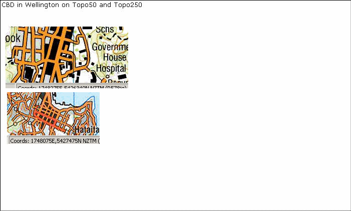
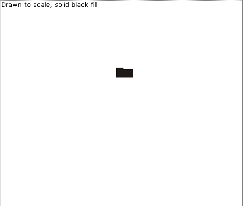
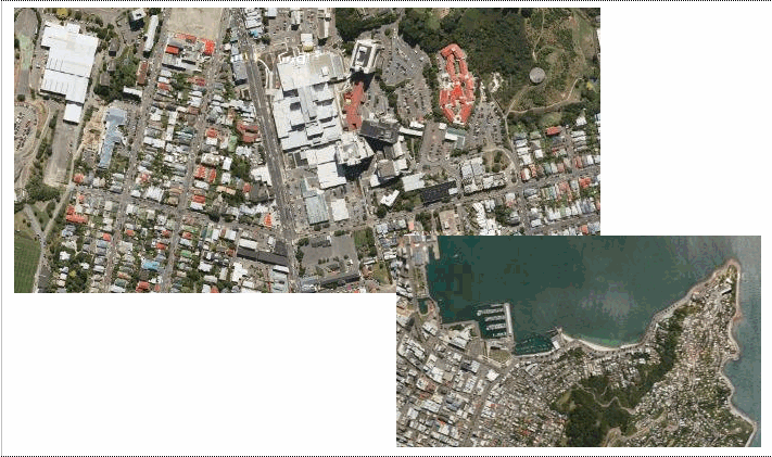
Building_poly is used to capture a building where it is large enough to be captured at 1:50,000 as an area feature (generally those larger than 25m square or other shape of equivalent area) . The CBD area of large towns and cities is held in the data as a large building_poly/s. It is shown on the printed maps as a black fill with the road features above.
Topo250 description
Only those significant by their size or location are held in the Topo250 data and shown on the Topo250 printed maps; these are a generalised subset of those shown on the Topo50 series
See also: building_pnt
Class attributes
| Attribute | Value |
|---|---|
| Object class | building_poly |
| Entity class | BUILDING |
| Additional entity class | BUILDING COMPLEX |
| Object inheritance | simple_area |
| Entity source | Proposed change to US Entity |
| Map series | Topo50 Topo250 |
| LSLIFF object class | 302 |
Object attributes
| Attribute | LSLIFF code Shapefile field Data type |
Attribute description | Attribute values* | |||||
|---|---|---|---|---|---|---|---|---|
| name | 1001 name string |
The name of the building, where known. Text data from July 2012 will be in UTF-8 format. If your system is not UTF-8 compliant, you will need to use the name_ascii attribute, which has had any macronated vowels removed. UTF-8 stands for Unicode Transformation Format-8. It is an octet (8-bit) lossless encoding of Unicode characters. UTF-8 encodes each Unicode character as a variable number of 1 to 4 octets, where the number of octets depends on the integer value assigned to the Unicode character. It is an efficient encoding of Unicode documents that use mostly US-ASCII characters because it represents each character in the range U+0000 through U+007F as a single octet. UTF-8 is the default encoding for XML. |
|
|||||
| name_macronated | 1140 macronated boolean |
Indicates whether the entry in the name_ascii field contains a macronated vowel. Where the value is "Y" go to http://www.linz.govt.nz/regulatory/place-names/find-place-name/find-m%C4%81ori-place-names-dual-names-and-alternative-names for a list of places or feature names within New Zealand that are gazetted and include macrons |
|
|||||
| building_use | 1014 bldg_use string |
For substation example see powerline_cl page. For sewage plant see pond_poly page. Note: Other legitimate building use attributes will be added periodically. | See below | |||||
| building_status | 1013 status string |
Values
|
|
|||||
| name_ascii | 9000 name_ascii string |
Text data from July 2012 will be in UTF-8 format. If your system is not UTF-8 compliant, you will need to use this attribute, which has had any macronated vowels removed. | ||||||
| UFID | 1000 t50_fid integer |
A unique identifier for use on Topo50 data in the LINZ Data Service. This is not a universal ID. The intention is to manage these ID’s as persistent, however this is not guaranteed and there will be instances where what appears to be a minor change to a feature may result in a new ID being assigned. |
|
* See explanation of attribute values for more information about how attribute values are represented.
building_use attributes values
| Value | Description |
|---|---|
| {empty} | |
| abattoir | |
| camp | |
| cement works | this attribute used exclusively for plants producing cement from raw materials. In 2009 there were 2. |
| church | |
| energy facility | a general description for a building which is usually part of a small compound associated with energy production. This value will replace "gas compound" "methanol plant" "natural gas plant" and "synthetic fuel plant" |
| factory | |
| fertiliser works | this attribute used exclusively for those plants in areas outside of the urban/peri-urban zone producing fertilizer from raw materials. In 2009 there were 7 known such plants. |
| fire lookout | |
| forest headquarters | |
| gas compound | |
| greenhouse | |
| gun club | |
| gun emplacement | |
| hall | |
| homestead | |
| hospital | |
| hut | |
| lodge | |
| marae | |
| methanol plant | |
| mill | |
| museum | |
| natural gas plant | |
| observatory | |
| polytechnic | |
| power generation | |
| prison | |
| salt works | |
| school | |
| shelter | |
| shingle works | |
| silo | |
| stamping battery | |
| substation | |
| surf club | |
| synthetic fuel plant | |
| university | |
| visitor centre | |
| water treatment plant |
Change log
| Feature version | Revised | Description |
|---|---|---|
| 15 | 2014-03-06 | nwe building_use value |
| 14 | 2012-08-28 | Updated map image and aerial view; added representation specification and example feature photographs |
| 13 | 2012-08-28 | Added scale-specific definitions |
| 12 | 2012-08-27 | Name attribute in UTF-8 format; added name_ascii attribute |
| 11 | 2012-08-16 | Name attribute in UTF-8 format; added name_ascii attribute |
| 10 | 2010-03-01 | Added name_macronated attribute and updated values for building_use |
| 9 | 2008-04-10 | Removed reference to seed and void objects |
| 8 | 2006-03-17 | new attribute value greenhouse replaces glasshouse and parliament for building use |
| 7 | 2003-06-30 | new attribute values |
| 6 | 2002-09-18 | new attribute value |
| 5 | 2002-06-18 | new attribute value |
| 4 | 2001-07-01 | new attribute value |
| 3 | 2000-11-01 | updated data type, new attribute values |
| 2 | 2000-03-31 | new attribute values |
| 1 | 1999-03-01 | initial status |