NZ Topo - object class height_pnt
This page describe the height_pnt object class used to represent objects in the NZTopo topographic database.
Description
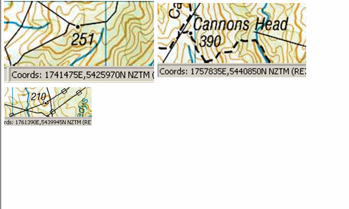
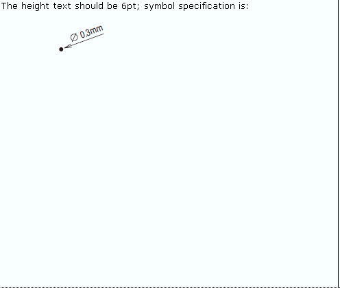
A height above a vertical datum, represented on a map by a dot locator with the elevation printed beside the dot. Unlike trigonometrical stations, spot heights are not identifiable on the ground
Topo50 description
Spot heights were captured by photogrammetry when the first edition 1:50,000 maps were created between 1976 and 1998. Height points are not present where a beaconed trig is located, even if the beaconed trig is not heighted.
Topo250 description
Mostly a generalised subset of those held in the Topo50 data are held Topo250 data and shown on the Topo250 printed maps; there will be instances of historic heights that exist in the Topo250 data, which don't appear in the Topo50, eg. in locations where, in the Topo50 data, a beaconed trig without a height value is present.
Ant50 description
Spot heights are only available in the areas captured by photogrammetry

Important information: Height_pnts in forest and snow areas may be less accurate.
See also: contour sinkhole_pnt
Class attributes
| Attribute | Value |
|---|---|
| Object class | height_pnt |
| Entity class | SPOT HEIGHT |
| Additional entity class | Not applicable |
| Object inheritance | graphic_point |
| Entity source | Proposed NZ Std Entity |
| Map series | Topo50 Topo250 Ant50 Topo500 |
| LSLIFF object class | 55 |
Object attributes
| Attribute | LSLIFF code Shapefile field Data type | Attribute description | Attribute values* | ||
|---|---|---|---|---|---|
| elevation | 1021 elevation real | The elevation above mean sea level. |
| ||
| UFID | 1000 t50_fid integer | A unique identifier for use on Topo50 data in the LINZ Data Service. This is not a universal ID. The intention is to manage these ID’s as persistent, however this is not guaranteed and there will be instances where what appears to be a minor change to a feature may result in a new ID being assigned. |
|
* See explanation of attribute values for more information about how attribute values are represented.
Change log
| Feature version | Revised | Description |
|---|---|---|
| 7 | 2012-08-28 | Updated map image and aerial view; added representation specification and example feature photographs |
| 6 | 2012-08-28 | Added scale-specific definitions |
| 5 | 2010-01-03 | removed attribute |
| 4 | 2001-11-23 | Unspecified update |
| 3 | 2000-03-31 | new attribute |
| 2 | 1999-10-01 | updated data type |
| 1 | 1999-03-01 | initial status |