NZ Topo - object class contour
This page describe the contour object class used to represent objects in the NZTopo topographic database.
Description
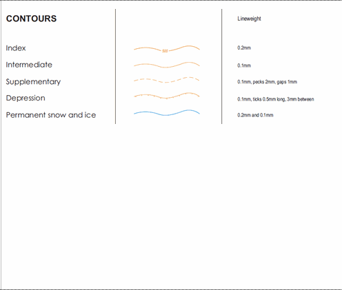
An imaginary line that connects points of equal height value eg the elevation of the land surface above or below a vertical datum, in this case of LINZ topographic mapping, this is Mean Sea Level.
Topo50 description
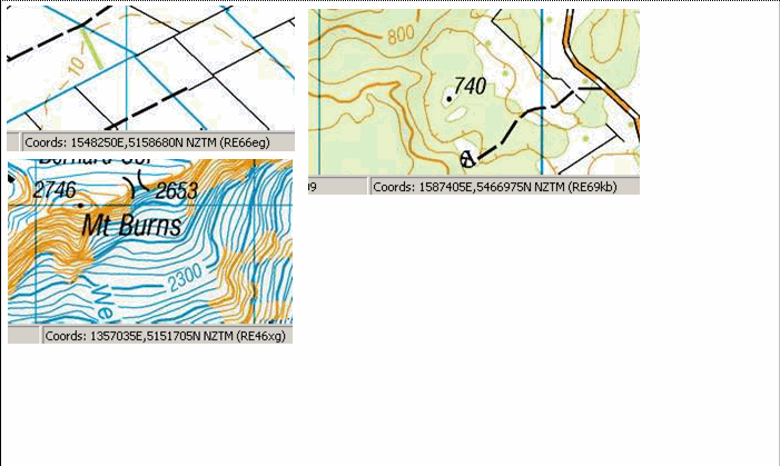
Contours at a 20m contour interval are held in the data and shown on the Topo50 printed maps. In very flat areas, some supplementary contours with a 10m contour interval are held in the data and shown on the maps. Note that there is no 0m contour, and that the coastline is mean high water mark
Topo250 description
Contours at a 100m contour interval are held in the Topo250 data and shown on the Topo250 printed maps; these are generalised from those shown on the Topo50 series
Ant50 description
Contours at 20m and 50m contour interval are held in the Ant50 data and shown on the Ant50 maps

Important information: Contours and height_pnts in forest and snow areas may be less accurate.
See also: coastline height_pnt sinkhole_pnt depform_edge
Class attributes
| Attribute | Value |
|---|---|
| Object class | contour |
| Entity class | GROUND SURFACE |
| Additional entity class | Not applicable |
| Object inheritance | graphic_line |
| Entity source | US Standard Entity |
| Map series | Topo50 Topo250 Ant50 Topo500 |
| LSLIFF object class | 26 |
Object attributes
| Attribute | LSLIFF code Shapefile field Data type |
Attribute description | Attribute values* | ||||
|---|---|---|---|---|---|---|---|
| contour_designation | 1023 designated string |
Values
|
|
||||
| contour_natural_formation | 1024 nat_form string |
Values
|
|
||||
| elevation | 1021 elevation real |
The elevation above mean sea level |
|
||||
| contour_definition | 1126 definition string |
Values
|
|
||||
| UFID | 1000 t50_fid integer |
A unique identifier for use on Topo50 data in the LINZ Data Service. This is not a universal ID. The intention is to manage these ID’s as persistent, however this is not guaranteed and there will be instances where what appears to be a minor change to a feature may result in a new ID being assigned. |
|
* See explanation of attribute values for more information about how attribute values are represented.
Change log
| Feature version | Revised | Description |
|---|---|---|
| 7 | 2012-08-28 | Updated map image and aerial view; added representation specification and example feature photographs |
| 6 | 2012-08-28 | Added scale-specific definitions |
| 5 | 2010-01-02 | updated comments section |
| 4 | 2003-06-30 | removed attribute |
| 3 | 2001-11-23 | Unspecified update |
| 2 | 2000-03-31 | comments, new attribute |
| 1 | 1999-03-01 | initial status |