NZ Topo - object class island_poly
This page describe the island_poly object class used to represent objects in the NZTopo topographic database.
Description
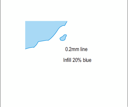
Area of dry or relatively dry land surrounded by water or low wetland
Topo50 description
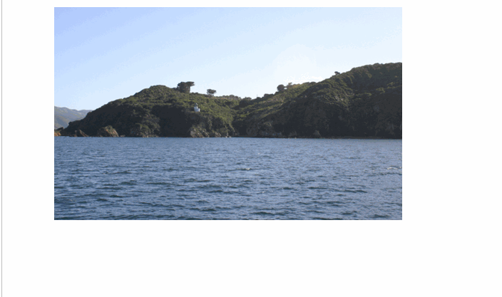
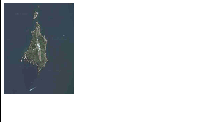
island_poly is used to capture all the significant (with respect to size) offshore and inland (eg within a lake or river) islands of New Zealand. Also used for the shores of the sub-antartic and islands of the Ross Sea Region. The North, South and Stewart Islands are all held as coastline features. The island_poly boundary for offshore islands is mean high water, MHW - see coastline for full explanation of MHW. Where an island_poly is close to a road, the printed map may only show the road representation; both features are held in the data. Where the island_poly is a wharf edge, the printed map may only show the wharf representation; again, both features are held in the data
Topo250 description
Only those significant by their size or location are held in the Topo250 data and shown on the Topo250 printed maps; these are a generalised subset of those shown on the Topo50 series

Important information: Permits may be required to visit some sensitive and special islands and areas. Contact the Department of Conservation to see if you need to apply for a permit.
See also: coastline
Class attributes
| Attribute | Value |
|---|---|
| Object class | island_poly |
| Entity class | ISLAND |
| Additional entity class | Not applicable |
| Object inheritance | simple_area |
| Entity source | US Standard Entity |
| Map series | Topo250 Ant50 Topo50 Topo500 |
| LSLIFF object class | 314 |
Object attributes
| Attribute | LSLIFF code Shapefile field Data type |
Attribute description | Attribute values* | ||
|---|---|---|---|---|---|
| name | 1001 name string |
The name of the island, where known. Text data from July 2012 will be in UTF-8 format. If your system is not UTF-8 compliant, you will need to use the name_ascii attribute, which has had any macronated vowels removed. UTF-8 stands for Unicode Transformation Format-8. It is an octet (8-bit) lossless encoding of Unicode characters. UTF-8 encodes each Unicode character as a variable number of 1 to 4 octets, where the number of octets depends on the integer value assigned to the Unicode character. It is an efficient encoding of Unicode documents that use mostly US-ASCII characters because it represents each character in the range U+0000 through U+007F as a single octet. UTF-8 is the default encoding for XML. |
|
||
| name_macronated | 1140 macronated boolean |
Indicates whether the entry in the name_ascii field contains a macronated vowel. Where the value is "Y" go to http://www.linz.govt.nz/regulatory/place-names/find-place-name/find-m%C4%81ori-place-names-dual-names-and-alternative-names for a list of places or feature names within New Zealand that are gazetted and include macrons |
|
||
| island_group_name | 1036 grp_name string |
The name of the group of islands that this island belongs to, where known. Text data from July 2012 will be in UTF-8 format. If your system is not UTF-8 compliant, you will need to use the name_ascii attribute, which has had any macronated vowels removed. UTF-8 stands for Unicode Transformation Format-8. It is an octet (8-bit) lossless encoding of Unicode characters. UTF-8 encodes each Unicode character as a variable number of 1 to 4 octets, where the number of octets depends on the integer value assigned to the Unicode character. It is an efficient encoding of Unicode documents that use mostly US-ASCII characters because it represents each character in the range U+0000 through U+007F as a single octet. UTF-8 is the default encoding for XML. |
|
||
| group_name_macronated | 1141 grp_macron boolean |
Indicates whether the entry in the group_name_ascii field contains a macronated vowel. Where the value is "Y" go to http://www.linz.govt.nz/regulatory/place-names/find-place-name/find-m%C4%81ori-place-names-dual-names-and-alternative-names for a list of places or feature names within New Zealand that are gazetted and include macrons |
|
||
| name_ascii | 9000 name_ascii string |
Text data from July 2012 will be in UTF-8 format. If your system is not UTF-8 compliant, you will need to use this attribute, which has had any macronated vowels removed. | |||
| island_group_name_ascii | 9001 grp_ascii string |
Text data from July 2012 will be in UTF-8 format. If your system is not UTF-8 compliant, you will need to use this attribute, which has had any macronated vowels removed. | |||
| UFID | 1000 t50_fid integer |
A unique identifier for use on Topo50 data in the LINZ Data Service. This is not a universal ID. The intention is to manage these ID’s as persistent, however this is not guaranteed and there will be instances where what appears to be a minor change to a feature may result in a new ID being assigned. |
|
* See explanation of attribute values for more information about how attribute values are represented.
Change log
| Feature version | Revised | Description |
|---|---|---|
| 10 | 2016-05-12 | Corrected SHAPE attribute name for group_name_macronated |
| 9 | 2012-08-28 | Updated map image and aerial view; added representation specification and example feature photographs |
| 8 | 2012-08-28 | Added scale-specific definitions |
| 7 | 2012-08-16 | Name attribute in UTF-8 format; added name_ascii attribute |
| 6 | 2010-07-06 | Added group_name_macronated attribute |
| 5 | 2010-03-01 | Added name_macronated attribute |
| 4 | 2008-04-10 | Removed reference to seed and void objects |
| 3 | 2001-11-23 | Unspecified update |
| 2 | 2000-03-31 | comments |
| 1 | 1999-03-01 | intial status |