NZ Topo - object class pylon_pnt
This page describe the pylon_pnt object class used to represent objects in the NZTopo topographic database.
Description
A steel tower supporting high tension wires
Topo50 description
Only those significant either by their size or location are held in the data and shown on the printed maps.

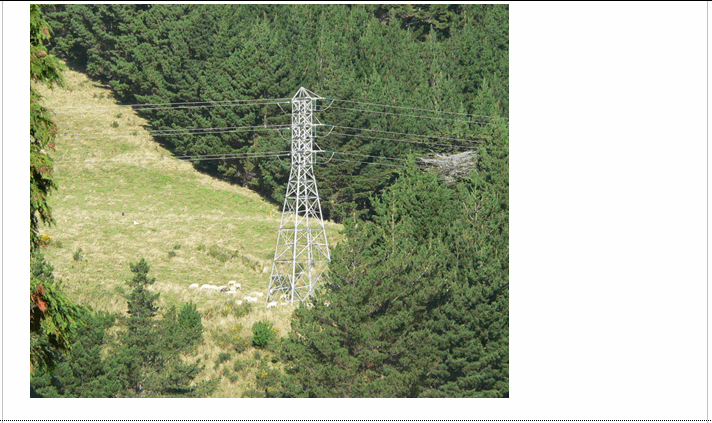

Important information: Not all aerial wires, cableways and obstructions that could be hazardous to aircraft are held in the data or shown on the printed maps
See also: powerline_cl
Class attributes
| Attribute | Value |
|---|---|
| Object class | pylon_pnt |
| Entity class | TOWER |
| Additional entity class | Not applicable |
| Object inheritance | simple_point |
| Entity source | US Standard Entity |
| Map series | Topo50 |
| LSLIFF object class | 99 |
Object attributes
| Attribute | LSLIFF code Shapefile field Data type | Attribute description | Attribute values* | |
|---|---|---|---|---|
| orientation | 1115 orientatn string | The orientation or angle of the feature as it is shown on the map. This is measured in radians starting from due east, in a counter- clockwise direction for positive numbers or clockwise for negative numbers. |
|
* See explanation of attribute values for more information about how attribute values are represented.
Change log
| Feature version | Revised | Description |
|---|---|---|
| 7 | 2020-04-08 | added orientation attribute |
| 6 | 2012-08-28 | Updated map image and aerial view; added representation specification and example feature photographs |
| 5 | 2012-08-28 | Added scale-specific definitions |
| 4 | 2010-03-01 | removed orientation attribute |
| 3 | 2002-06-18 | new attribute |
| 2 | 2001-11-23 | Unspecified update |
| 1 | 1999-03-01 | intial status |