NZ Topo - object class road_cl
This page describe the road_cl object class used to represent objects in the NZTopo topographic database.
Description
Any formed all weather route suitable for the passage of any vehicle.
Topo50 description
Most named roads are held in the data and shown on the printed maps. Be aware that there is no distinction in the data or on the printed maps between public and private roads. Un-named roads in rural areas shorter than 300m may not be captured. Also, not all motorway ramps in complicated spaghetti junctions are necessarily held in the data. Where 2 or more roads are in very close proximity, the roads held in the data and shown on the printed maps may be offset from one another to a distance of up to 30m - motorway on and off ramps are frequently offset;
Topo250 description
Only those significant by their size or location are held in the Topo250 data and shown on the Topo250 printed maps; these are a generalised subset of those shown on the Topo50 series
Important information: The existence of a road or track does not necessarily indicate public right of access
See also: bridge_cl cattlestop_pnt ford_pnt gate_pnt track_cl tunnel_cl
Class attributes
| Attribute | Value |
|---|---|
| Object class | road_cl |
| Entity class | ROAD |
| Additional entity class | Not applicable |
| Object inheritance | simple_line |
| Entity source | US Standard Entity |
| Map series | Topo50 Topo250 Ant50 Topo500 |
| LSLIFF object class | 123 |
Object attributes
| Attribute | LSLIFF code Shapefile field Data type |
Attribute description | Attribute values* | |||||||||||
|---|---|---|---|---|---|---|---|---|---|---|---|---|---|---|
| name | 1001 name string |
Road names are sourced from the LINZ Data Service layer NZ Roads Subsections (Addressing) https://data.linz.govt.nz/layer/3383-nz-roads-subsections-addressing . NOTE road names are not added where the road forms part of a roundabout (in accordance with the ICSM Roads Data Model).
Text data from July 2012 will be in UTF-8 format. If your system is not UTF-8 compliant, you will need to use the name_ascii attribute, which has had any macronated vowels removed.
UTF-8 stands for Unicode Transformation Format-8. It is an octet (8-bit) lossless encoding of Unicode characters.
UTF-8 encodes each Unicode character as a variable number of 1 to 4 octets, where the number of octets depends on the integer value assigned to the Unicode character.
It is an efficient encoding of Unicode documents that use mostly US-ASCII characters because it represents each character in the range U+0000 through U+007F as a single octet. UTF-8 is the default encoding for XML.
Values
|
|
|||||||||||
| name_macronated | 1140 macronated boolean |
Indicates whether the entry in the name_ascii field contains a macronated vowel. Where the value is "Y" go to http://www.linz.govt.nz/regulatory/place-names/find-place-name/find-m%C4%81ori-place-names-dual-names-and-alternative-names for a list of places or feature names within New Zealand that are gazetted and include macrons |
|
|||||||||||
| LOL_SUFI | 1131 rna_sufi string |
This is a unique identifying number given to the Electoral/Landonline Road Centreline ID. It replaces the name_ID attribute in earlierTopo Road Centreline layers. This will enable users a direct link via the IDs to the NZ Road Centre Line (Electoral) layer |
|
|||||||||||
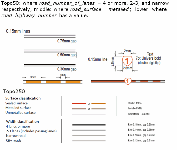
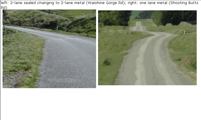
| road_surface | 1080 surface string |
Values
|
|
|||||||||||
| road_status | 1081 status string |
|
||||||||||||
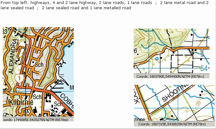
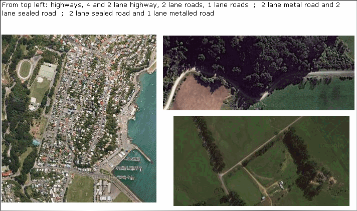
| road_number_of_lanes | 1082 lane_count integer |
The number of paths available side by side for the simultaneous passage of vehicles on a road. Values
|
|
|||||||||||
| road_highway_number | 1083 hway_num string |
Values
|
|
|||||||||||
| road_one_way_two_way | 1085 way_count string |
Values
|
|
|||||||||||
| name_ascii | 9000 name_ascii string |
Text data from July 2012 will be in UTF-8 format. If your system is not UTF-8 compliant, you will need to use this attribute, which has had any macronated vowels removed. | ||||||||||||
| UFID | 1000 t50_fid integer |
A unique identifier for use on Topo50 data in the LINZ Data Service. This is not a universal ID. The intention is to manage these ID’s as persistent, however this is not guaranteed and there will be instances where what appears to be a minor change to a feature may result in a new ID being assigned. |
|
|||||||||||
| road_width | 1127 width string |
This attribute is used primarily for roads that fall in between 1 lane and 2 lanes in terms of their physical width. It is applied primarily when the road_number_of_lanes attribute = 1. This attribute is being populated over time.Values
|
|
* See explanation of attribute values for more information about how attribute values are represented.
Change log
| Feature version | Revised | Description |
|---|---|---|
| 12 | 2017-07-24 | Added road_width attribute |
| 11 | 2016-08-24 | Updated attribute description for 1 lane roads |
| 10 | 2012-08-28 | Updated map image and aerial view; added representation specification and example feature photographs |
| 9 | 2012-08-28 | Added scale-specific definitions |
| 8 | 2012-08-16 | Name attribute in UTF-8 format; added name_ascii attribute |
| 7 | 2010-03-01 | Updated attribute description road_one_way_two_way and added name_macronated attribute. Updated comments section. |
| 6 | 2005-09-06 | new attribute value for road_number_of_lanes |
| 5 | 2003-06-30 | new and removed attribute values |
| 4 | 2003-05-27 | updated attribute value |
| 3 | 2001-11-23 | Unspecified update |
| 2 | 2001-03-05 | comments |
| 1 | 1999-03-01 | initial status |