NZ Topo - object class track_cl
This page describe the track_cl object class used to represent objects in the NZTopo topographic database.
Description
A deliberately formed route of a lesser quality than a road
Topo50 description
Only those significant either by their size or location are held in the data and shown on the printed maps.
Topo250 description
Only those significant by their size or location are held in the Topo250 data and shown on the Topo250 printed maps; these are a generalised subset of those shown on the Topo50 series
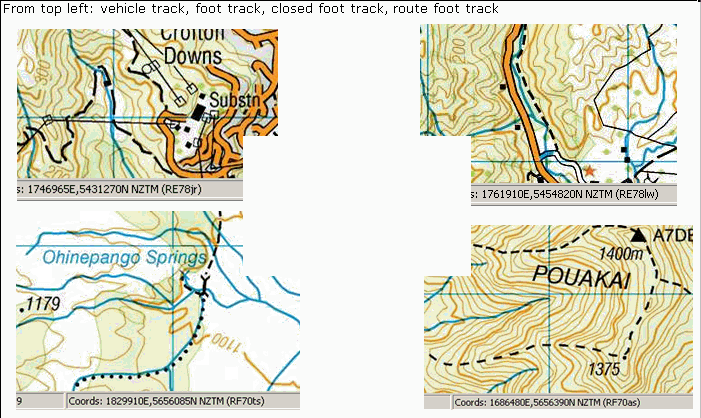
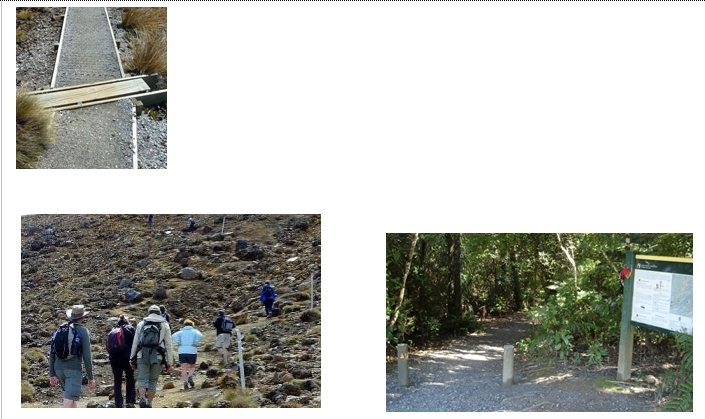
Important information: The existence of a road or track does not necessarily indicate public right of access. Closed foot tracks are defined as being no longer maintained or passable and should not be used by recreationalists; the Department of Conservation or other authorities should be contacted for the latest information on tracks. Foot tracks in alpine areas are of a varying degree of spatial accuracy and currency; contact Department of Conservation for the latest information about alpine tracks.
See also: bridge_cl cattlestop_pnt gate_pnt ladder_pnt ladder_cl road_cl tunnel_cl
Class attributes
| Attribute | Value |
|---|---|
| Object class | track_cl |
| Entity class | ROAD |
| Additional entity class | Not applicable |
| Object inheritance | simple_line |
| Entity source | Standard Entity |
| Map series | Topo50 Topo250 Ant50 |
| LSLIFF object class | 171 |
Object attributes
| Attribute | LSLIFF code Shapefile field Data type |
Attribute description | Attribute values* | |||||||
|---|---|---|---|---|---|---|---|---|---|---|
| name | 1001 name string |
Name of the track, where known. Text data from July 2012 will be in UTF-8 format. If your system is not UTF-8 compliant, you will need to use the name_ascii attribute, which has had any macronated vowels removed. UTF-8 stands for Unicode Transformation Format-8. It is an octet (8-bit) lossless encoding of Unicode characters. UTF-8 encodes each Unicode character as a variable number of 1 to 4 octets, where the number of octets depends on the integer value assigned to the Unicode character. It is an efficient encoding of Unicode documents that use mostly US-ASCII characters because it represents each character in the range U+0000 through U+007F as a single octet. UTF-8 is the default encoding for XML. |
|
|||||||
| name_macronated | 1140 macronated boolean |
Indicates whether the entry in the name_ascii field contains a macronated vowel. Where the value is "Y" go to http://www.linz.govt.nz/regulatory/place-names/find-place-name/find-m%C4%81ori-place-names-dual-names-and-alternative-names for a list of places or feature names within New Zealand that are gazetted and include macrons |
|
|||||||
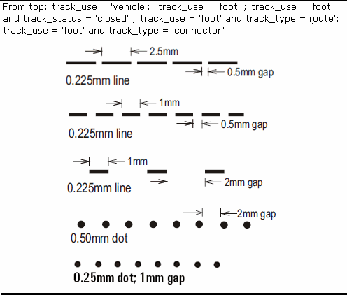
| track_use | 1101 track_use string |
Values
|
|
|||||||
| track_type | 1102 track_type string |
Values
|
|
|||||||
| track_status | 1136 status string |
Values
|
|
|||||||
| name_ascii | 9000 name_ascii string |
Text data from July 2012 will be in UTF-8 format. If your system is not UTF-8 compliant, you will need to use this attribute, which has had any macronated vowels removed. | ||||||||
| UFID | 1000 t50_fid integer |
A unique identifier for use on Topo50 data in the LINZ Data Service. This is not a universal ID. The intention is to manage these ID’s as persistent, however this is not guaranteed and there will be instances where what appears to be a minor change to a feature may result in a new ID being assigned. |
|
* See explanation of attribute values for more information about how attribute values are represented.
Change log
| Feature version | Revised | Description |
|---|---|---|
| 15 | 2020-05-27 | Removed unknown value for track_status |
| 14 | 2020-04-01 | Changed track_type from poled route to route |
| 13 | 2015-08-28 | Added connector value for track_type |
| 12 | 2015-08-28 | Updated definition for poled route |
| 11 | 2013-12-16 | New value for track_use |
| 10 | 2012-08-28 | Updated map image and aerial view; added representation specification and example feature photographs |
| 9 | 2012-08-28 | Added scale-specific definitions |
| 8 | 2012-07-16 | Added new value (unknown) for status |
| 7 | 2010-03-01 | Added description for poled route and added name_macronated attribute. Updated Comments section and closed track definition. |
| 6 | 2006-09-01 | Changed attribute value for unmaintained vehicle track status. |
| 5 | 2006-05-30 | Changed attribute value for closed foot track status |
| 4 | 2003-06-30 | new attribute |
| 3 | 2001-11-23 | Unspecified update |
| 2 | 2000-03-31 | new attribute value |
| 1 | 1999-03-01 | initial status |